With winter temperatures swinging into the 50s and the snow-free ridgeline of the Bridgers visible from Bozeman, Bridger Bowl has postponed its community ski racing events scheduled for this weekend.
The ski resort announced Thursday it was postponing the King and Queen of the Ridge fundraiser race scheduled for Saturday, Feb. 3 and the community Dual Giant Slalom race series scheduled for Sunday, Feb. 4.
“Due to current snow conditions and warm temperatures, King and Queen of the Ridge and Dual GS #3 will not be held this weekend,” Bridger Bowl posted on social media Thursday. “Stay tuned. Details coming soon.”
On Saturday there will still be live music by Lost Canyons in the Jim Bridger Lodge and a promotion of MAP Brewing’s Midas Crush beer, according to the Instagram story.
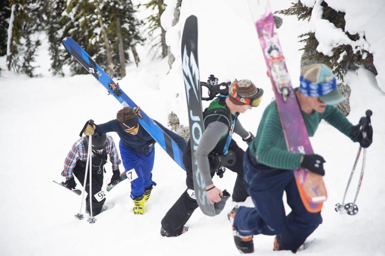
The annual King and Queen of the Ridge event is the second-biggest fundraiser for the Gallatin National Forest Avalanche Center. Racers try to complete as many laps hiking to and skiing down the Ridge as they can, and whoever does the most laps wins. The event organizers guarantee “prizes, camaraderie and a good time.”
The beloved local tradition depends on enough snow to withstand the barrage of repetitive bootpacking and chute skiing, and a relatively low avalanche risk. But this year, a steady snowpack is a rarity across Montana, and warm conditions have increased the risk of wet slides.
As of Jan. 31, the Gallatin Basin recorded snowpack levels that were 55% of what they normally are this time of year. The Madison Basin snowpack was 61% of normal and Upper Yellowstone Basin snowpack was 55% of normal.
In the Bridgers, Gallatins and Madisons, the wet snow avalanche danger for Feb. 1 was high.
“This is the 4th day in a row with no freeze or a light freeze in the mountains around Bozeman and Big Sky,” the avalanche forecast read. “The thin, exceptionally weak snowpack, is susceptible to wet slab avalanches on sunny slopes. We don’t have a lot of experience with wet slides on a thin snowpack this early in the winter, but we recognize it is dangerous.”
The Gallatin National Forest Avalanche Center’s Director, Doug Chabot, added his thoughts in an Instagram post last week, writing that “unusual weather leads to unusual avalanche conditions… This year is unique in my 29 years of avalanche forecasting in southwest Montana.”
Despite the conditions and race postponements, this weekend could see a slight boost to the snowpack.
Starting Friday evening and falling in waves through Sunday, the Gallatin Valley and surrounding mountains are set to get snow.
The valley floor will see between 1 and 3 inches, and the surrounding mountains could get anywhere between 6 and 10 inches, and potentially 14 inches at the highest elevation peaks.
The snowfall won’t be super heavy but on the heavier side of the snowstorms that have happened this winter, National Weather Service meteorologist Scott Coulston said.
He added people should still be careful driving on icy roads.
“This is not a real significant storm but still a change from what we’ve been seeing,” Coulston said.
Let the news come to you
Get any of our free daily email newsletters — news headlines, opinion, e-edition, obituaries and more.
Send us your thoughts and feedback as a letter to the editor. Submit by email, by post to 2820 W. College St., Bozeman, MT 59718 or use our online form.
Support quality local journalism. Become a subscriber.
Subscribers get full, survey-free access to the Bozeman Daily Chronicle's award-winning coverage both on our website and in our e-edition, a digital replica of the print edition.